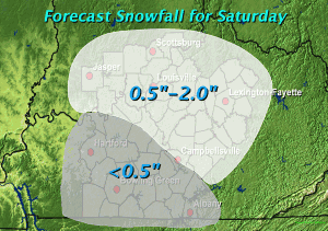
Snow Accumulations up to Two Inches Forecast for Saturday
A clipper system will swoop down from the northwest into our area by early Saturday. Precipitation with this system will arrive in the form of light snow Saturday morning. As temperatures warm Saturday afternoon, precipitation will change to rain over south central Kentucky and a rain/snow mix over north central Kentucky and southern Indiana. Some locations closest to the cold air over southeast Indiana and the northern Bluegrass in Kentucky may remain all snow Saturday afternoon or just experience a brief mix. Saturday evening precipitation will change back over to snow before tapering to flurries around midnight. The image below depicts preliminary forecast snowfall amounts for this system.
Following this clipper system, much colder air will be ushered into the region with high temperatures not making it out of the 30s next week. In fact, high temperatures for Monday and Tuesday are expected to be below freezing! Low temperatures will only be in the teens and low 20s.


