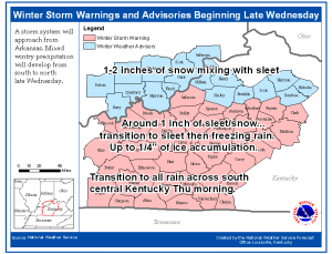
Winter Storm Will Affect The Region Wednesday & Thursday
 The high pressure responsible for the Arctic airmass currently in place across the area will shift east into the Appalachians on Wednesday. At the same time a low pressure system is forecast to develop across the central and southern Plains states. Warm moist air from the Gulf will move northeast of this low and into our region. Initially as the moisture moves in here…light snow should start to fall across south central Kentucky early Wednesday…with the snow progressing north through the day. As more warm air moves in above the surface…the ice will melt and then re-freeze as it hits the cold air nearer the surface. At this time, a changeover to sleet and then freezing rain is forecast to occur across south central Kentucky Wednesday afternoon. This transition zone will shift northward Wednesday night, reaching north central Kentucky and southern Indiana before daybreak Thursday and remaining there through the day as the low pressure moves near the Kentucky/Tennessee border.


