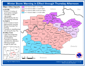
Updated Winter Storm Snow & Ice Forecast
 The high pressure responsible for the Arctic airmass currently in place across the area will shift east into the Appalachians today. At the same time a low pressure system is forecast to develop across the central and southern Plains states. Warm moist air from the Gulf will move northeast of this low and into our region tonight. Initially as the moisture moves in here…light snow should start to fall across south central Kentucky…with the snow progressing north this evening. As more warm air moves in above the surface…snow will become sleet and rain and then re-freeze as it hits the cold air nearer the surface. Snow…sleet and freezing rain will overspread our entire region tonight…with the heaviest precipitation ending by daybreak Thursday.


